The two Bleichert Pendant Tramways at Wentworth Falls and Katoomba
by
Philip Hammon.
GLADSTONE COLLIERY AND KATOOMBA COAL AND SHALE CO.

Between 1880 and 1883 Robert Henry Reynolds, a land developer and general wheeler-dealer from Sydney, purchased under Mining Conditional Purchase (M.C.P.) several lots of land near Wentworth Falls in the Blue Mountains of NSW, Australia, underneath which he believed was mineable coal, and which he hoped could be subdivided and sold to become building blocks. By 1885 he had secured the land and he and 6 others put together a syndicate to open up the “Lower Coal Seam” between Leura and Wentworth Falls in the Blue Mountains of New South Wales to be known as the Gladstone Colliery. Land was obtained under “Mining Conditional Purchase” for £20 an acre, requiring an outlay of £2 an acre as a deposit, the balance being payable in two years, or the land being forfeited if no improvements had been undertaken within this period. With the purchase of the land went a Mining Right to any minerals found therein except gold. Often, as in this case, the purchase money was borrowed against the security of the land, a strange arrangement to our eyes, as the land was subject to forfeit!
Reynolds with his eye on saleable land, bought Por 97, which is 50 acres at the tip of today’s Sublime Point, then two adjacent 80-acre portions, Por 90 in Oct 1880, Por 89 in Feb 1881, and a 40-acre portion 91 in Feb 1881, and a 40-acre Por 88 in April which was later extended southward to include another 12 acres. The most important as far as Gladstone Colliery was concerned was Por 159 and 153 in April 1883, which gave him access for the pendant tramway the design of which was, by this time, well under way. The mine was to extend under Por 88 and 89 heading Northward under Isobel Bowden ridge.
Conveniently, the connecting block of land between Reynold’s land and the railway siding, was owned by Campbell Mitchell, [born 1831 and died in 1883] Por 67 C Mitchell 20.3.0 C786 .1507 (Grant No. 6 in 1878) See Fig B.
An acquaintance of both North and Reynolds, he was the son of Sir Thomas Mitchell, the road constructor of 1832. Some arrangement must have been made before his death for this access, as there is no indication of a lease across his land for the Ropeway. But it is highly likely that Reynolds finished with a route for his ropeway through Pors. 159,153,174,157 and Campbell Mitchell’s Por.67.
Note: Relative monetary values.
£20 in 1883 equates to the following in 2017: –
Real price using inflation – $2,282
Labour Value using average weekly earnings – $16,920
Economy Share using the proportion of population who had that sort of money $170,660.
Current value of land in that area (2018) for building is $2M an acre.
Reynolds purchases:
Por 90 Oct 14th, 1880 80 acres Por 89 Feb 17th, 1881 80 acres
Por 97 June 15th, 1881 50 acres Por 88 April 21st, 1881 40 acres
Por 153 April 5th, 1883 40 acres Por 159 April 12th, 1883 40 acres
Por 174, 175 (15 acres each) and Por 157 of 20 acres were on the ropeway line but the Lands Dept map is a later date and does not show the original purchaser.
Total land purchased 380 acres, cost £7,600, deposit £760 – Today’s value $6.5M. So, he was investing serious money.
The original investors and office holders in the Gladstone Coal Company Limited (GCCL)were: –
Robert Henry Reynolds – 2.5% -Begg St. Paddington
Ernest Farish Stephen – 16% -Abbotsford, Albermarle St, Newtown. (son of Lieutenant Governor Sir Alfred Stephen C.B, K.C.M.G, M.L.C.)
Matthew Henry Stephen Q.C. (Chairman of Gladstone Coal Company Limited )-5.5% – Barrister 103/110 Elizabeth St, Glenayr, Glenmore Road, Paddington.
Dr Rudolph Schutte, M.D. L.S.A. – 12.5% – 16/10 College St Sydney
Francis E Rogers – 7.5% -Barrister 105 Elizabeth St.
Frank Senior J.P. – 47/51 Phillip St Sydney
J F Holle – Rockley House Elizabeth Bay Road. Tailor 285 George ST.
Louis Cohen – 9.5% -auctioneer,93/125 Pitt St., Eurella, Queen St. Woollahra. – he auctioned the land parcels on the opening day. See Fig A.
James Milson – 7% – Willoughby St. St. Ives.
G R Stephens – G R Stevens who were shipping agents.
Alderman Joshua Jeremiah Farr – (Managing Director of GCCL) builder, George St Redfern.
H W Callen – picture frame maker 410/420 George St. Sydney
Adolphus Rogalsky – 4.4% -Glebe Road, Glebe.
Charles Bate – 7.3% -property agent, Old South Head Rd. Woollahra. He put his 500 shares up for sale on 20th May 1885.
E F Ickerson (legal manager)- not listed in Sands although a prominent lawyer. – Solicitor Mutual Fire Chambers 86 Pitt St. On 15th April 1887 he defended Oscar Schulze in his attempt to recover money from GCCL. He was the official liquidator of GCCL in July 1887.
Mr Pile (vice chairman)
Details from Sands Directory
- J. B. North was listed in 1883 as stock and share broker 105/139 Pitt St.
- Frederick Hammon, my G. Grandfather was listed in 1883 as watchmaker and jeweler, 130/138 King St.
- Benjamin Backhouse who bought Por 68, Por 72 and Por 92 and with Campbell Mitchell Por 71, was a well-known architect of 263 George St Sydney. Backhouse was the Chairman of the “City Improvement Board”.
The Maitland Mercury of 16th July 1885 reports that the company was prepared to deliver coal to Redfern Station for 11/3 per ton.

This Real Estate brochure (Fig 1.0) has been supplied by Brian Fox. Rosebery and Bate Streets still exist, Alfred St is now West Street. All the blocks in Sec 1 and Sec 2 were never developed, Sec 3 was re-subdivided, as the modern blocks do not match. The site of the steam Sawmill is now a dirt car park for bushwalkers. Note the addition of a railway station to serve the “Township” and a path on the left “Track from the Coal Mine” See Por 67 and 68 in Fig 1.1 and 1.2 below.
This map raises an interesting question. The ropeway would have passed through lots 11,12,27 and 28, making them a little difficult to sell.
Also access for the ropeway across the Bathurst Road would have to be dealt with via an easement. The terminal of the ropeway had to include bins for storing coal and delivering it to the railway trucks on the siding underneath. This had to be on Railway property, and also dealt with through some lease or easement. I have not been able to find any documentation to support this.
On 21st June 1884 the Daily Telegraph reports that Reynolds and Cohen approached the Minister for Works to plead for a siding to serve their ropeway. The minister replied that they should pay for it themselves, but that he would look further into the matter. The Sydney Morning Herald and the Sydney Mail printed a similar but more detailed report, which illustrated Mr Cohen’s ability to bend the truth to his own advantage when quoting financial figures. On the 25th June the Newcastle Morning Herald enters the debate as to who should be paying for infrastructure which rewards the investor but not the Government.


Unfortunately, this mine had a very short life and not much is known of its operations, the Government inspectors only reporting six monthly, the first report in June of 1885 saying it was being constructed, the next in November that it had closed, but the first report did mention the Tramway and that it was being installed by one Oscar Schulze C.E. (Consulting Engineer) and Carl Wagermann.
Usually referred to as “Captain Wagermann” he came to Australia as a representative of various firms in Germany for the Melbourne Exhibition of March 1881. He and Schulze became the “patentees” for Bleichert Ropeways in Australia. He appears in Victorian Newspapers as being involved in various mining ventures in Victoria.
Newspaper reports of the Gladstone Mine opening day tell of the special train laid on, the banquet and toasts in a specially erected tent, and the huge expectations of riches to flow both from the coal and the land sales of the surrounding MCP land. Mention was also made of the miles of “rails” lying on the ground ready for installation of the railway to transport the coal. Not surprisingly the journalist of the day was unfamiliar with Pendant Tramways and had never seen track rope sections before, so he fell back on calling them “rails”.
As the coal mine was 200 meters below the level of the railway line on the escarpment and distant 2 miles, a Bleichert Pendant Tramway was commissioned to carry the coal from the mine to the railway siding. For the descent from the ridgetop to the mine level, a convenient gully was utilized which kept the gradient of the Tramway to an average 21 Degrees.
As the mine was, and still is, surrounded by rainforest, on a steep talus slope at the foot of 100 metre cliffs, we know very little of the tramway terminus, other than the newspaper reference that the tramway buckets were brought in pairs from the mine on special trolleys, pushed under the transport rail, where the carriers were hooked on, then as the carrier was pushed further along the rail the track sloped down and the bucket and carrier were lifted off the trolley. (Fig 1.3). The carrier was then pushed around to where it could be clipped onto the haulage rope and transported to the top of the gorge.
This system did have the advantage of not having to tip the coal, with the provisions of hoppers and chutes which all would have taken up valuable space on the steep talus slope, but had the disadvantage of the lip of the bucket being 3′ 6″ high, so the seam being worked had to be at least 4′ 6″ to allow shoveling of the coal into the buckets by the miners.
An excursion in 2017 found the following:
There are two tunnels, about 30 metres deep, the larger on the left and the smaller ventilation on the right, both tunneling in a Northerly under Elizabeth Bowden Ridge. This direction is not surprising, as the adits are near the Southern Boundary of Por 159 of Reynolds’ land.


There is a large leveled area in front of the tunnels which extends about 20M to the West. This is apparently the holding area for empties and bucket trolleys.
The tramway terminus is on the Eastern side of the creek to the East of Elizabeth Bowden Ridge. There must have been a bridge across the creek to access the terminal area at the same level as the mine adits.
We presume that the buckets on their trolleys were manually pushed across this bridge.


This rope sheave (Fig 1.6 and 1.7), is lying just below the bottom station of the ropeway and is very likely to be their haulage rope return sheave, as its approximate diameter is 6′ 6″ the gauge of the ropeway. It has an oversized groove, to accommodate the “spiders” which were inserted into the rope lay, for the carrier grips to engage with.

The aerial tramway had the drive on top of the cliffs, where it also changed direction by 18 Degrees to send the buckets on to the specially built railway siding on the NSWGR. The siding was at the 65 1/2-mile mark from Sydney, which is opposite today’s “West St.”, was installed in 1885, and was 813′ long. The siding was closed in 1887.
The position of the siding shown on a modern Google Map (Fig 1.11) is shown in Red, based on a Singleton sketch map from “Shale Railways of NSW”. Blaxland Road is branching off at lower left, and Sinclair Crescent at very bottom right.
The NSWGR empties (8 Ton capacity S Trucks) would have been brought up the single line track from Sydney. Shunting operations then left the empties on the high end of the siding and the train would proceed on its way.
The trucks would be filled by allowing them to run under the hopper, fill, then further into the dead-end siding to await pickup.
Collection is a little more complicated, as an “up” engine (bound for Sydney), would have to stop West of the siding, lock off its train, then proceed into the siding and draw the trucks up until the front truck was clear of the up points. Then, lock off the trucks, uncouple, back onto the mainline, change points, forward to past the Up points, change points, back into the siding and couple to the trucks, then draw them out of the siding onto the main line, stop change points, then back up to couple to the rest of the train, then proceed up to Sydney. (Even though “up” is downhill that’s railway talk)
In a long article in SMH 13th July 1885 many details of the ropeway installation are listed. http://nla.gov.au/nla.news-article13592813
This article mentions a “Rools” tubular boiler. A typo, as it should be “Root” boiler manufactured by Patent Boiler Company of Birmingham, in the UK. See below. This ties in with the mention of a “self-feeding Grate” which is mentioned in this advertisement. (Fig 1.9)
Root Boilers were manufactured by the Patent Boiler Company, Heneage St Birmingham UK and were a water tube boiler.


Here is a similar discarded bevel gear – Fig 1.16 on the island of Svalbard where Bleichert supplied many ropeways, the first in 1907.
The Katoomba drive sheave (which has not survived) had 6 grooves and the two counter sheaves have two grooves each (Fig 1.31). In the drawing above, the track ropes are terminated at the drive, but at Gladstone they were carried through, and fitted with substantial buttresses to take the lateral forces produced by bending the drive 18 degrees.
Unfortunately, the footings for the winder are buried under the earthworks for a golfing tee. The Leura Golf Course was extended to 18 holes in 1925 through this area. Only two concrete foundations were visible in 2005. One was of a unique design, (Fig 1.17) being a four feet square column about 3′ high with a 2’3″ hole in the top 6″ deep closing down to a 2′ diam. hole filled with debris, which we assume was the flue for the steel tubed and guyed boiler chimney. Further works by the Fairmont Resort in 2015 resulted in the removal of this artifact.

Nearby is a flat half buried concrete footing, possibly a boiler foundation.
We have had a ground penetrating radar scan done of the area (Fig 1.18) with zero result. Disappointing, but there has been a lot of earthmoving activity in the area since the golf club was extended to 18 holes in 1925, and the Fairmont Resort built nearby in 1988.


Fig 1.18.
The GPR survey did not yield any result. Too much disturbance, tree roots and fill.
Water Supplies
At the bottom of the slope to the East is a dam, (Fig 1.19) currently supplying water for the Leura Golf Club, but it doesn’t show on the 1943 or 1970 aerial photos of the area, so it was not built to supply the Bleichert Boiler. Where did they get their water from? An 80 HP twin cylinder steam engine would use 2,600 Gallons working over an eight-hour day.
There is a possible dam showing in the 1943 SixMaps picture at Lat. 33:43:19.12S Long 150:21:12.1E. The telling fact is the walking track visible in the 1943 photo Fig 13B (Blue Arrow) curving around to exactly where the dam is today (Red Arrow) and continuing away to the East, angling towards the SE corner of DP751646. Apparently, the Leura Golf Course Dam was built on or near to the site of the Schulze Dam for the Gladstone Coal Mine. By the time this 1943 (Fig 1.20) photo was taken the Schulze Dam had been abandoned for 59 years and may be the grey blob just below the red arrow tip. On the 1969 Topographic map of Katoomba a “tank” is marked on the site of the Gladstone engine. It could mean the concrete chimney footing (Fig 1.17) as an abandoned GI tank is not likely to have lasted 85 years.


Tension Pit
Five hundred meters down line at Lat 33:43:6.94S Long 150:21:14.55E is a concrete tension pit, 24 ft. long 6 ft. wide and 12 ft. deep. (Fig 1.22).

There are substantial foundation bolts on the Northern side, (Fig 1.24) indicating to me that this was the anchor point for the track ropes extending past the winder and down into the valley. The track ropes from the rail siding end were tensioned here and fixed at the siding end. When the ropeway was moved to Katoomba a Tension Pit of similar size was built there to contain 4 weight boxes so why this pit is 24ft long when it only had to accommodate two weight boxes instead of four, I don’t know. The weight boxes were approx. 5’ square. They may have contained these 56-pound weights, cast iron filled with lead (Fig 1.23).
We found this one at the Northern Terminal of the Ruin Castle Ropeway, where it had been used to weigh the incoming buckets.
Tension pit equipment:
In the pit were two hanging cradles designed to hold the 40 cast iron weights, 1/2 cwt. each, (56 pounds or 25 kg) we are still doing the reverse engineering on the Jamison installation to calculate how much mass was needed to tension the track ropes. The mine end of the Gladstone installation would not have needed much mass, but the tension station between the drive and the unload station would need much more.


Nearby is a tree stump, (Fig 1.25) cut at an angle with a saw, in quite good condition. It is very possible that this is an original stump, its survival being due to the smooth upper surface shedding water, photos taken 5/12/11. Checked with Bushfire Brigade, they have no record of fires going through the area.

Where the siding was, for many years a large lump of concrete lay beside the highway, from the siding terminus, but disappeared when widening works were undertaken on the road.
A few hundred metres to the West of the unload terminal in 1885 was a level crossing. The Western Road deviation constructed by Thomas Mitchell from Wentworth Falls to this level crossing circa 1832 on the Southern side of the railway line, passed under the tramway ropes beside the hoppers, yet in the contemporary correspondence of the time there has not survived any account of this unfamiliar sight!
A small 100 metre section of this road remains, at the rear of Kedumba Park as it turns to cross the railway line at the level crossing.
The Gladstone Colliery closed after shipping only 745 tons of coal up to the railway siding with the Pendant Tramway, the work of about 5 days. The figure of 745 tons comes from NSWGR records of shipments out of the Gladstone Siding.
The return sheave from the siding end of the ropeway is now outside the Glen Shale Mine in the Megalong Valley 5 miles away. (Fig 34)
We do know that John Britty North was operating the Katoomba Coal and Shale Company in 1888 and had been looking for a way of developing his Oil Shale deposits 2 miles from his coal mine across a 600-foot-deep forested Jamison valley. His exploratory mine at the Ruined Castle was reported closed in the Evening News of 3rd Sept 1885 as he waited. He did have a report from consultants suggesting that Aerial Tramways were a feasible solution to this problem, and as some of his MCP land was bought in partnership with Robert Henry Reynolds in the late 1870’s, he was well aware of the existence of the Gladstone Ropeway, and of its availability, and he was a guest at the Mine Opening! At the auction sale on 22nd April 1887, under the verandah of the Supreme Court in King St Sydney, North bought the Ropeway with all its engine, boiler and plant.
Oscar Schulze C.E.
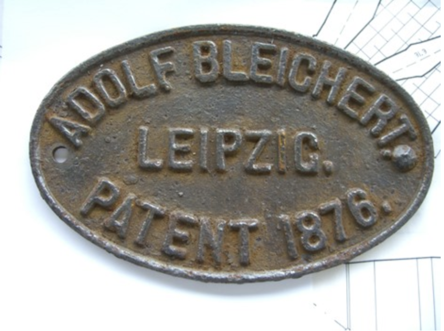
Oscar arrived in Sydney on 1st Sept. 1879 aged 31 from the USA. He was immediately involved in the 1879 Sydney International Exhibition, (1-8-79 to 30-9-79) as a representative of several German firms. It was noted “he speaks good English and is very courteous”. In Melbourne in April the following year, he was joined by Captain Wagemann, of Melbourne, as agents for many machinery firms, this time including Adolf Bleichert of Leipzig. An operating ropeway was erected out the back of the German Court viz. “One of the latest novelties is an aerial line of railway, erected in the open air, by the Lake, at the back of the German court, central annex.” By this time Wagemann and Schulze were “patentees” for the aerial ropeway. This “sample” ropeway was soon reused to transport soil across the Yarra River to create approaches for a bridge. Some of this equipment was then reused at Wentworth Falls and Katoomba resulting in premature failures.
Oscar was an accomplished pianist and performed at social functions on Dangar Island during the Hawkesbury River Bridge erection. – HRRB
Oscar Schulze, meanwhile, was in the midst of trying to recover £3,400 from the owners of the Gladstone Colliery through the courts for the Bleichert Ropeway that he had installed. He had been paid £4,150 for the plant and materials but had not been paid the balance because of the work had not “being completed” to the satisfaction of the defendant. Schulze lost the case and was denied any further funds. I’m sure he was more than happy to have North make an offer for the hardware, and for him to retrieve, re-engineer and reinstall the Ropeway.
It seems that Schulze had borrowed money from the mining supply company, Rabone Feez to pay Adolf Bleichert for the ropeway, so the purchase price supplied by North went to Rabone Feez and Schulze was happy to have a job.
SMH 15th April 1887
REYNOLDS AND OTHERS AGAINST SCHULZE OSCAR
ON FRIDAY, the twenty-second day of April 1887 at noon, unless the Writ of Fieri Facias herein be previously satisfied, the Sheriff will cause to be sold by public auction under the verandah of the Supreme Court, King Street Sydney the Pendent Railway connecting the Gladstone Coal-mining Company’s Mine with the Great Western Railway near Went- worth Falls, together with engine, boiler, and plant in connection with the said Pendant Railway.
Terms, cash.
CHARLES COWPER
E.F. Ickerson, Defendant’s Attorney, Sydney
In 1888 Schulze was still involved in the erection of the Hawkesbury River rail bridge (Figs 1.26 & 1.27), for The Union Bridge Company of Pennsylvania. This bridge was opened for rail traffic on 1st May 1889.
For the full story on the bridge see Bill Phippen’s marvelous book “The Hawkesbury River Railway Bridges” published by Australian Railway Historical Society. (HRRB)

His wife gave birth to a daughter on Dangar Island in the Hawkesbury River on 10th July 1888. -SMH 21st July 1888
So, he was a busy man if he was also involved in the Gladstone and Katoomba installations.
Carl was married to Helene Forsyth in 1885, and Archie was born in 1886 in Ryde.
We know that he moved to Katoomba to supervise the erection of the Ropeway for North, because his 2-year-old son Archie was buried in Katoomba Cemetery after succumbing to “mesentric glandular disease” possibly Tuberculosis, on 6th April 1889. (Fig 1.28). The Hawkesbury River Bridge was opened 25 days later, to which Schulze was invited but not confirmed to be present.
Sands Directories:
1885 Schulze Oscar, consulting engineer 331 George St. (Gladstone Mine being built)
1886,1887 Schulze Oscar civil engineer 313 Kent St.
1888 Not listed. Living in Katoomba? (18th July held discussions with John Whitton re Caisson N0.5 of Hawkesbury River Bridge.)
1889 Not listed. Letter about arrears of rates Hunters Hill Council. April 24th, involved in testing on Hawkesbury River Bridge. 1st May, invited to Bridge opening. (Phippen)
1890 Not listed
1891 Not listed
1892 Schulze Oscar William St Hunter’s Hill
1893 Schulze Oscar Dick St Hunter’s Hill

A timeline of newspaper mentions of Schulze’s involvement with the Bleichert Ropeway in Katoomba.
20th April 1888 – Schulze places ads for contractors to erect the “Tightening Station”.
6th April 1889 – Archie buried in Katoomba cemetery.
15th June 1889 – A piece of track rope is being replaced. – Nepean Times
22nd June 1889 – Lots of shale being sent up by Mr. Schulze from the mines – Katoomba Times
17th August 1889 – Mr Smith, manager for Mr Schulze at the Katoomba Shale Mine, met with an accident…. – Katoomba Times and others.
31st August 1889 – Mr Schulze has a new contract for the supply of Katoomba shale …… – Katoomba Times
7th September 1889. – Mines Stopped. – Wages cheques did not appear – Nepean Times
28th Feb 1890 -North and Schulze in Chambers before Mr Justice Foster re a Promissory note that had been repaid but not notified to the court. – SMH
March 1890 – NSWGR – Henry Deane has caissons of Hawkesbury River bridge inspected, and Union Bridge undertakes repairs that take 9 months. – HRRB
21st June 1890 – Schulze appears before City Railway Commission. – Daily Telegraph
23rd Oct 1890 – A daughter is born to Oscar’s wife on Dangar Island. (In the Hawkesbury River – where they had been living during the Bridge construction, and subsequent corrective works) – Australian Star
Apparently, the financial crisis besetting J. B. North commencing from March 1889, had resulted in Schulze leaving his employ after 7th September 1889, and he has gone back to Dangar Island to be involved in the repairs to the pylons.


An American ad for the Bleichert system, (Fig 1.29) manufactured in USA by Trenton Iron Company. http://www.vonbleichert.eu/trenton-iron-american-wire-us-steel/ This is 9 years after the manufacture of the Katoomba System and many changes had been made. Notably the rope grips, and the transition to fully locked coil track ropes, the two things that caused most failures in the Katoomba system.

There are no known pictures of Schulze, even though he was very active in the German community in Sydney, even printing a German Language newspaper.
On 13th August 1887 the Nepean Times reports that:-
The discovery of a seam of payable shale has induced the company to purchase the pendant railway formerly used by the Gladstone Coal-mining Company, near Wentworth Falls, and they now propose to spend £20,000 more in fully developing the shale as well as the coal resources.
Retrieving the Ropeway from Gladstone and re-erecting it across the Jamieson Valley was no mean task in 1888.

Bush tracks were the only means of access, and bullock drays or traction engines the only means of moving heavy equipment.
There was a rail siding at Wentworth Falls in 1886 to where the original Ropeway was delivered, and we surmise that at that time the equipment was transported in many bullock dray loads via what is now Blaxland Road and across the rail line at level crossing #9, behind what is now Kedumba Park.
The unload terminal equipment and the ropes, then went East 150M to the site of the future siding, the balance was taken on the easiest grade route a further 2 miles to the Gladstone drive site.
Land department maps of 1896 show a thin line where today Sinclair Crescent runs, indicating a bush track. There was also a road alongside the railway line, today’s Railway Parade. It is possible that this road was used. We do not know, as it may have been obliterated when the railway was duplicated in 1902.
Short list of equipment to be moved.
80 HP steam boiler and metal chimney, possibly 5 tons.
60 HP steam engine and base, 6 grooved drive sheave, two double grooved counter sheaves, possibly 6 tons. These had to be lifted with tripods and chain blocks. Timber framing.
The counter sheaves have survived and are presently displayed outside the Tea Rooms in the Megalong Valley, after they were recovered from their subsequent use (1892-1903) as turn wheels on the Glen Shale Mine tramway. (Fig 1.31)

These double grooved sheaves are designed to be assembled on site, as the hubs are split and clamped on to the shaft with shrink rings. The hubs are keyed to the shaft. For a full explanation go to
The tower fittings consisting of rope saddles, tower caps, haul rope rollers, right angle brackets and, depending on the tower design, 2″ square iron bars with a single wheel fitted to each end. See Fig 1.32 picture of the top of Tower 45 These would all have to be recovered by hand once the ropes were recovered.
Schulze had a very difficult task in rebuilding the ropeway at a site that it was not designed for.
He had a drive that was double ended, and he only needed a single end, producing unequal forces on the drive.
He only had one tension station where he needed a second one down near Cascade Creek.
He had to improvise a haul rope tension arrangement at the drive, where the original had a haul rope tension sheave at each end of the double drive, one of which was, and still is, at the bottom of the cliff at the Gladstone Mine.
The Gladstone Drive was 2000M long, with a bucket every 60M, he had 66 buckets, and an equal number of spiders to insert in the haulage rope. He probably bought new haulage rope because removing and reinserting the existing spiders at a longer spacing, would leave gaps where the core had been removed for the spider, a potential rope failure at every one. The Ruined Castle Ropeway was 3,400M long and the buckets had to be equally spaced, so the spacing went out to 103M.
The approach angle of the track ropes at the cliff edge of the Northern Terminal was very steep, exceeding the design limit of 45 degrees. Maybe this was the idea behind installing the “C” brackets on every bucket frame, to limit the upward pull on the rope grip.
He was also limited in the number of Tower heads, rope saddles and haul rope wheels that he had, so I theorise that he had to keep the number of towers to an absolute minimum.
The only thing that he had a surplus of, was the rails that diverted the carriers around the drive station at Gladstone, as when it was re-erected at Katoomba the drive was separate to the ropeway line.
He had three of the “double tower heads” and he used one at the Southern Station Fig 3.2 and 3.5, one at the Tension Station Fig 6.2 and one for Tower 10, Fig 3.16. I surmise that at Gladstone, one was used to launch the valley span down to the mine terminal, and one on each side of the gorge of the headwaters of Valley of Waters Creek.
He also had a number of “Sliding saddles’ Fig 3.15. I don’t think that we have recorded all of them, but their obvious intent is to deal with large amounts of track rope movement across towers. It seems that they weren’t a huge success as all the ones we have recovered have had the track had one end broken off. Fig 8.7.
Labour to build the ropeway wasn’t as much of a problem as it could be today, as there were plenty of men with experience working with both steel and hemp ropes on sailing ships. Bill Phippen’s photos of work on the Hawkesbury River Railway Bridge show long lengths of hawser and chain stretched across the river being used to position the caissons, which had both steam and manual winches arranged to wind in and out. Schulze worked on the Bridge erection as a consulting engineer.
CHAPTER 2 DESIGN DETAILS

Tower Design
The standard towers were basically a tripod with a cross-arm on top.
The two angled legs were installed vertical to the track rope angle and the prop leg was installed on the downhill side of these. (see sketch Fig 26 and Fig 27)

– Tim Vollmer – A prop leg with its single bolt still in place. The top of the leg has been tapered to fit between the two main legs and the bolt acted as a pivot as the tower was pulled upright then held the prop in between the main legs.
The cross-arm was held in place with a head-plate and supported by two right-angled brackets made of cast iron. The head plate was held in place by 6 bolts, which went right through the angled legs. The right-angled brackets were held by bolts which went transversely through the angled legs and also up into the cross arm.
On top of outside ends of the cross-arm were bolted cast iron saddles which supported the track ropes and allowed them to slide back and forth. These saddles were of varying lengths depending on the load and the deflection angle across the tower.
Seven feet below the cross-head were two timbers bolted either side of the angled legs. These supported the haulage rope wheels and a “gathering plank” which was there to stop large swings of the haulage rope caused by cross winds, and to ensure that the haulage rope dropped onto the roller. Ladder rungs were nailed to the prop leg.
These tripod towers were approximately 30 feet high and approx. 50 yards apart depending on terrain. The gauge (distance between the centres of the track ropes) of the ropeway was 6’8” so the cross-arms were 6’10” long and were cut away underneath for clearance of something(?).
There were variations on these tower designs, the one shown in Fig 1.32 has a double head. (Figs 51 – 54) This was to deal with large changes in track rope deflection. It consisted of an extra set of angled legs sprouting from just above the haulage rope cross bars, clamped at the top with a head-plate and angle brackets. On top of each of the two cross arms was bolted a square section iron bar, with a wheel turning on a stud at each end. The wheels were 6” in diameter and with a groove suitable for the two sizes of track rope. The two cross arms were spaced apart with two round bars approx. 1” in diameter and 6’ long. There were 4 of these arrangements used in varying configurations, Towers 10, 13, 19? and 44-45.
The next tower design was a simple Tee, (fig 35) only 7’ high with two angled sawn timber legs, a cross-arm with head plate and right-angle brackets. The bottoms of the legs were spaced with 8”x1” planks on either side, with the haulage wheels on the ground underneath. The tower was angled to equalise the track rope angle on either side.
The 2 legged “approach tower” in Fig 25 appears to be a later addition to further ease the change of angle across Tower 45.

The two angled legs were cut away to fit together and fit the brackets. The bracket bolts both held the brackets in position and clamped the leg tops together and 4 or 8 more kept the cross arm in position. The 6 head plate bolts clamped the legs longitudinally and held the cross arm in position.
Brackets were used both with the 8 bolts through the cross arm, and with 2 bolts clamping the legs and also 4 bolts through the cross arm and 4 bolts clamping the legs.
Assembly and erection.
Firstly, the two angled legs are laid out with their bases just uphill of the holes dug to stand them in and their tops uphill. Their tops are supported on a strong sawhorse to make assembly easier.
Because the cross arms had already been drilled at Gladstone, as these sawn timbers were re-used complete with saddles, the brackets would be bolted to the cross arm, then the pole tops cut away – probably with axes – so that the brackets fitted on either side and the head plate fitted over them. Then the holes for the clamping bolts would be marked, the brackets removed and the 12” deep holes drilled with a brace and bit coming out exactly to line up with the bracket on the other side. The brackets and cross arm are then bolted into place.
Next the head plate is fitted, and these 6 holes have to be drilled through 6” of leg and cross arm, lining up with the hole on the other side. These guys were master craftsmen!
The prop leg was cut away for its top to fit between the angled legs and a single 1” bolt drilled all the way through all three legs, a 30” deep hole! This bolt acted as a pivot as the assembly of legs was pulled upright – probably using a crab winch – and the base of the prop leg was dragged out to its hole.
At some sites, where it was rocky, only a small depression was cut for the base of the legs, and they were held in place by a wall of stone blocks.
Remember, every piece of equipment had to be carried to site by hand, the country was too steep for ponies. Inclines were used with crab winches in the steeper sections, evidenced by remaining lengths of web rail.
Track ropes.
The track ropes were of at least three different sizes, 13/12/6/1 32mm diameter, (Fig 29) and 12/6/1 30mm diameter (Fig 30) and 12/6/1 25mm diameter. They were in 100 Metre lengths and each end was fitted with a Bleichert patent screw coupling (Fig 31).


Total rope weight something in the region of 30 Tons.
The Bleichert couplings posed a particular problem when being re-assembled. They were designed to be screwed together using a double threaded ferrule, RH and LH so they could be screwed together in one operation. They were then prevented from unscrewing because of the natural rope twist, by drilling a hole through the threaded section using a hole already supplied in the outer of the socket, and then inserting a soft metal pin through and peening over the ends. Reusing these holes would be impossible because of misalignment of these holes unless every ferrule and socket were individually marked to keep the sets together. Hence the reason for quite a few of these joints not having pins reinserted when the ropeway was reinstalled.
Removing the track ropes from Gladstone would not be easy. Firstly, the lead filled cast iron tension weights (Fig 1.23) would have to be unloaded from their cradles. How do you then get 2 tons of cast iron blocks back to the top of the cliff?? Then starting at the bottom, the track ropes would be lifted out of their saddles and lowered to the ground. Bearing in mind that this operation is not taking place on smooth flat ground but on a steep rocky slope. Then the rope sections have to be separated.
First the old pin would have to have the head filed off and driven out, and the ferrule unscrewed, separating the lengths of rope.
Then the haul rope would be used to winch out the lengths of rope, a threaded plug screwed into the socket with a chain attached. The chain would be “snaffled” around the haul rope in front of a spider, and then easily pulled out of the valley.
Seeing as our previously mentioned journalist noted many lengths of “rail” lying on the ground, at the opening ceremony, we can assume that there was spare rope on hand.
Pells and Hammon wondered where the extra track rope came from to make up the extra 3000 feet of travel needed for the Ruin Castle installation. Maybe it was there anyway, Bleichert being aware of the failure rate of wires on their track ropes. In 1881 Schulze and Wagemann erected a ropeway across the Yarra River in Melbourne to move soil for the abutments of a bridge. It is possible that some of the equipment came from there. http://nla.gov.au/nla.news-article5970943
The haul rope is the last to come out, the splice cut first, and the winder used to feed the rope onto hand-fed wooden reels. Quite a job, I have personally hand wound 1200 feet of 7/8″ rope onto a reel, and it takes four men, about 3 hours and a lot of sweat.
I imagine reel sizes were governed by what could be lifted and transported. The haul rope could have been “figure-eighted” on a flat top dray, that would be possible as the transport distance was only about 6 miles.
Rope installation across the Jamison Valley.
The general plan is to install the haulage rope first then use it to pull the lengths of track rope into position, screw the couplings together, and lift the ropes up onto the saddles in the cross arms.
Wire ropes run downhill very easily, all that is needed is a man walking downhill to guide the leading end and a braked feeding mechanism. However, as this system goes both up and downhill what was probably done was to feed two lengths of 8-gauge fencing wire across the valley, one on each side of the towers. The uphill end could be pulled by a team of men, then wind the Western side up onto a crab winch at the Mine end, pulling the tail of the haulage rope across the valley around the turnwheel then use the winder to pull it back again with the other length of fencing wire. Communication is the problem with this operation as the winch has to feed the right amount of rope as the wire is pulled from the Mine end. This may have been done with flags, a man perched on top of a tower in sight of the next man with two different coloured flags, would achieve the object. This has to be done twice, once on each side, (East and West) and the wire on the Eastern side then used to pull the tail of the haulage rope back from the mine to the winder. [The ropeway ran anti-clockwise, empty buckets on the Western side going out to the Mine and loaded buckets coming back on the Eastern side.]
Then the haulage rope is spliced to make a complete loop and the winder can be used to pull the 100M lengths of track rope into position resulting in these grooves in the rocks as they are dragged across them. (Fig 1.37 & 1.38)


The Gladstone rail siding return sheave (Fig 1.40) also posed a problem with disassembly and re-deployment.

The spokes could be unbolted, and the rim separated from the shaft, but the rim is in one piece, providing an unwieldy load. The Gladstone installation had two return sheaves, one in the valley and one at the Railway Siding. Fig. 1.40 is the Railway Siding one now remaining in the Megalong Valley at the site of The Glen Shale Mine. The one outside the Gladstone mine is still in situ, but needs to be exposed, measured and photographed. Fig, 1.6 and 1.7
It would be logical to re-use the one at the Northern end, which was much more accessible. However, this sheave had to be transported to the Ruin Castle mine site before the haul rope could be installed. There was only one practical route, and that was over the cliff off the Narrow Neck. We have recently (June 2020) discovered a cutting on the top of the Neck (Fig 1.41) which may have been for clearance for a flying fox to carry heavy equipment down into the valley near the mine site. Lat 33 45 07 Long 150 17 01. However, I have not been able to locate any bolt holes or fixings at the edge of the cliff where such a flying fox would have to have a small tower or davit.

The sides of the cutting are well fallen in, indicating great age. The fill from the cutting has been dumped at the bottom of the cutting to provide a platform, big enough to turn a horse and cart around.
Bleichert Ropeway installed at Katoomba to the Ruin Castle Shale Mine

This beautiful photograph Fig 1.42, by Henry King shows Tower 7 on the edge of the cliff, a Tee tower about 2 ½ metres high. Towers 8 and 9 can be seen on the ledge below, and the rest of the ropeway stretching away in the distance to the Oil Shale Mine. I will have further analysis of this photograph in a separate chapter.
Once all the equipment had been assembled at the Katoomba Mine site, the erection process could commence.
The surveyors need a credit here. For the most direct route from the Northern Terminus to the Mine, the first three hundred meters of the ropeway line brush along the side of a 200-metre cliff, and across two ledges halfway down the cliff face. Surveying the cable line across this area necessitated much tree clearing and roping up 45-degree talus slopes, to draw the ground profile. Then the Ropeway engineers, here we probably mean Schulze, had to use this profile to determine the tower sites. (He made two mistakes that I know of, Tower 8 had serious uplift problems and had to be extended by 3M, and Tower 43 was so low that they abandoned it. Tower 12 had to be seriously modified, and a cutting made to ease the change of gradient).
The route alignment was a difficult decision. Consideration had to be given to the distance that the shale had to be brought from the mine adit to the hopper for the ropeway if it was moved to the East to avoid the cliff edge and the problem of Tower 10. (See separate chapter)
There was also very convenient hill on the direct line, above the crossing of Cascade Creek which gave a long span of 250M saving a number of towers if the ropeway was otherwise routed East down the adjacent gully.
Problems also arose later from this choice of route where the severe change of slope at Tower 12, caused track rope failures and de-ropings.
Of course, an aerial ropeway of this type must go in a straight line, unless there is a major structure, as they had at Gladstone, to change direction. At Gladstone this was also the driving station, but at Katoomba the driving station had to be remote from the terminal, because of the difficult site and water and fuel supply. Gladstone was mining coal, so it was relatively easy to divert some coal at the driving station to fuel the boiler, but Katoomba was mining shale, and the coal had to come from the adjacent coal mine which was being brought up the incline from the mines in the valley.

Fig 1.43. Slightly optimistic map of the mine area, showing miners cottages both alongside Ficus St. and also on the site of the current CMS property East of Ivy St. It does show the location of the ropeway engine room -blue square –
The entire town of Katoomba was divided in half by the Tramway, hence the footbridge at the bottom of Burrawang St.


Fig 1.44. The scales of the 2 maps do not match.
Violet ST – Red
Ficus St – Yellow
Burrawang – Blue
Google Earth
Twenty metres to the NW of the blue square in Fig 1.43 is this anchor ring, 1 metre below ground and solidly bedded in concrete. (Fig 1.441) This was the anchor ring for the ropeway drive. When the ropeway was installed at Gladstone it had two ends and the thrust on the drive sheave was roughly equaled on each side. (Fig 1.15) When the drive was installed at Katoomba there was only one side used, so the thrust from the haulage ropes had to be countered, so the timber framing for the drive was tied back to this anchor ring.
The Tension Pit
A convenient site also had to be chosen for the tension station. The tension station was necessary to limit the tension on the track ropes where they are anchored at the top of the cliff. The longer they are, their own weight will eventually become too great and the factor of safety will fall below the accepted value of 2. (In 1889, two was the accepted value, in 2018 it is 5.5 to 6!!!) A tension station is basically a set of rails which the buckets run up onto, off the rope, see Fig 22D, so that the rope can be terminated, coupled to a chain, and that chain (Fig 22C) is directed over a specially shaped sheave, (Fig 22A), below which is suspended in the pit a large box weighted with stone or iron weights. This does two things, assures a minimum tension for the rope at the tension station and allows movement of the rope out into the rope spans as the buckets reach mid span then back again as they reach the towers.


Fig 1.47 – Tim Vollmer
This frame held the top of the weight box together and is made from tapered strip.

The Track rope rests on the slipper and can slide in the gap between the rail and the slipper. The slipper will be much closer to the rail than in the photo, so that the fastening bolt holes are aligned. The truck wheels can then easily run up off the rope and up on to the top of the rail.

So, the site chosen for the tension station must have a level area of 30Mx10M, solid foundations, no water ingress, i.e. not in a creek bed, we don’t want it filling with water. Ideally a level approach and depart for the track ropes. This cannot be achieved however, because of the line of the haulage rope, sloping up the hill from one supporting idler wheel to the next, so the entire tension station rail system has to be installed at an angle of approximately 20 degrees, hence the reason for the pit only being 9ft deep instead of 12 ft at Gladstone. The rails were elevated 9 ft at the Northern end. The haulage rope is pulling approximately 13 700kg buckets and carriers uphill from the creek crossing, giving a rope tension of 1.6 tonnes. This system has no facility for controlling upthrust on the haulage rope, so it has to be left to run in a straight line, and the Tension Station has to follow suit.
There was a Tee tower just a few metres North of the transit rails, to minimise the load from the ropes on the transport rails. We don’t want the rails getting bent from an overloaded bucket, or as proved to be the case, a bucket getting unhooked from its carrier at one end then dragging on the ground as it approached and wrecking itself and the carrier. (Fig 1.50)

Fig 1.50 – This carrier has had an adventurous life. The carriage has already been smashed and replaced with a fabricated one (the square box behind the wheels) and the idler wheel has a piece broken out of it. This carrier had had its bucket pin jump out of its trailing arm hook and hang down, bending the hook. The bucket had then “engaged with terrain” dragging the whole assembly down so far as to make it hit the ground and bend the front arm also.

Fig 1.51 – This carrier has a broken rope grip mount and the leading arm is bent away because of a bucket hanging on the front pin. It was a common problem, the bucket pin jumping out of its hook as the carrier crossed a tower. Even though 40 buckets are spread across the valley floor, no modifications were undertaken to prevent this happening.

As can be seen in Fig 1.511 this was not an uncommon problem. This 1904 ropeway in Chile has had a bucket detach its front pin.
Immediately to the South of the Tension Pit was a double topped tower made from the type of hardware used on Tower 45. Two 2.5M long flat bars were fabricated and used to space the tower heads apart. . (Fig 1.52 and 1.521). The slight bulge where the hole for the bolt was punched by the blacksmith can be seen. (Red arrow)


The length of the bolts indicate that the tower was constructed of 6″ timbers. A very strong and squat double tower only 3 or 4 metres high, similar in construction to Tower #7 in Fig 1.42 .
Tower 10
A most remarkable structure was conceived for tower 10, (Fig 1.53), straddling a series of ledges, the outer legs of the tower were 20 meters high, and the track rope supports suspended under a large cross beam.
We have recovered the suspended tower head (Fig 1.54) complete with bolts and washers, so we are able to size the timbers which acted as spacers for the two cross members, and under which the head was suspended.
The iron cross members were turned on their sides so that they could be clamped together with an 11” timber spacer in between.
The top timber was probably a 12”x12” about 27’ long.
The four long bolts on which the head hung were clamping two 10” square blocks between the upper and lower timbers. This provided some rigidity and lateral strength.
The wheels on the ends of the cross members are supposed to allow the track ropes to work across the tower as span lengths change when buckets cross from one side of the tower to the other.
In reality the track ropes are so rigid and their contact with the wheel is so small that gaining sufficient torque to turn such a small wheel is questionable, it is much more likely that the ropes slid across the wheels. However, there is no wear mark to indicate that this happened.


Constructing this tower with only manpower on the steep slope with the uprights cut from native timbers, was a remarkable feat. Standing the 10 metre poles on top of one another, after bracing the top of the lower poles back to a narrow ledge, was probably done with a crab winch and davit on the upper ledge.
The site consists of three ledges. The upper narrow ledge to rest the main cross beams on. The large middle ledge that the buckets pass across, and the narrow lower ledge, to which the tops of the lower legs were tied back.
An expedition to these ledges to look for hold down bolts was undertaken in April 2018 however thick scrub made progress impossible.
A drone investigation hasn’t revealed much more.
We expect to find on the upper ledge the following bolts:
Anchors for the two cross beams under which the track ropes were suspended. At least 4×1″ bolts 12″ long were held in the rock with lead, either pounded in or poured molten.
On the “major” ledge: –
At least 4 smaller bolts for the windlass. Sockets in the rock for the base of the davit. Anchors for the davit tie back lines. All these bolts should be complete with nuts and washers, as the timbers have long been burnt in bush fires or just rotted away. However, I suspect that many or all of these have been removed by the subsequent miners, for reuse elsewhere. But a quirk in engineering standards may have prevented this, as any of the bolts supplied by Bleichert, had Bleichert’s own thread profile and pitch, and a nut from them would not fit any other bolt.
At the base of the tower, the practice was simply to locate the poles in a shallow hole without bolts, or even to locate them in a stack of squared off stone blocks, there being very little lateral loads on the towers. So, these two holes have probably long eroded away. All the local timbers other than Turpentine rot very quickly when lodged in a hole in this manner, and are prone to attack by termites, so Turpentine was probably the timber of choice. Some of the Turpentine tower poles used across the valley are still, in 2011, lying where they fell, scorched by bushfires but still intact.
Towers 11 and 12 were simple tripod towers.

Tower 13:
Tower 13 had two versions.
The first, a Tee tower on the top of a rocky outcrop, probably had a 30-degree deflection to tower 14 down the steep slope towards the tension pit, with track ropes only supported on 6-inch saddles resulting in very high pressures on the wires.
There are 2 lengths of both inbound and outbound ropes coiled in the bush just over the foot track edge. (Fig 1.58).
The ropes have severely flattened wires, a result of the large downforce from the carriers caused by the large deflection across this tower, and, a single 2.5M long wire has been pulled from the outbound rope and kinked at 200mm from the end. This is the result of a wire breaking where it rested on the saddle of Tower 13 and being pulled out by the passing truck. This was an excellent reason for immediately stopping the drive and designing a solution.
These two lengths of inbound and outbound rope have been cut out of the original ropes, and the outbound rope was replaced with a 40M piece of solid 25mm diam. round bar. Brian Hemsworth from Australian Winch and Haulage advises that it is possible to coil rod like this for transport, so it can fit on a rail wagon. The inbound rope was replaced with a new piece of rope.
The solution to this problem was to make a cutting through the rock for the buckets to pass through, dropping the level of the tower by approx. 8 metres and moving the tower to the top end of the cutting, reducing the deflection at tower 13 to approx. 30 degrees.
In (Fig 1.60) you can see that there are 4 insulators on top of tower 13, indicating that there were two cross beams. We can’t see if there were two uprights, but there probably were, each standing at a different angle to absorb the down-thrust of the ropes.


The damage to the track ropes is more easily repaired once they can be closer to the ground, so the construction of the cutting was done first. To do this the 4 ropes that were supported on Tower 13, had to be temporarily held up with timbers, while the cutting was made under them, using jump bars and black powder or maybe even the newly invented, gelignite. The timbers that were used for this job can be seen on the LHS of Fig 1.60.

An interesting point is that the current walking track which crosses the track ropes, is approx.5 metres wide. The cutting would have been started from the bottom and the rock allowed to fall downslope as it was broken up, forming the bench that you see today. As more rock was blasted down, it was pushed over the edge keeping the working surface level and making the bench.
King’s photo shows this new tower 13 to be a Tee Tower. Also the timbers used to support the Track and haulage ropes while the cutting was being cut can be seen on the left of the picture.
About 100M down the line of the ropeway from the walking track, there is a large flat, upon which the remains of a pisé hut were visible in the 1970’s. This was a construction workers hut. It was about 10M long and 3M wide.


Where the cutting reached and went over the crest of the hill the spoil was then dumped over the side of the hill, as can be seen in the photo Fig 1.60.
At the head of the cutting a rock has been pick marked to clear it away for this tower, Fig 1.61 and a small area has been flattened to accommodate the haul rope wheel.
While we are talking about this particular part of the ropeway, it is interesting to note: –
In 2011 the inbound rope which had been buried for a 1 m length on the outside edge of the foot track, (i.e. Federal Pass) broke, and exposed the rope which had been buried. To our surprise the rope was badly damaged with many outer wires broken and pulled back, and even the inner wires showing flattening from carrier wheels. (Fig 1.62). For this type of damage to occur the rope would have had to be resting in a slipper, which implies that there was a tower at this point.
However, sometime prior to mining recommencing in 1925, a substantial landslide had occurred just South of where the #3 adit is today, pulling the two ropes up the hill about 20 metres. So, the damage was caused on Tower 14. See detailed explanation see below.

The damage to the rope was substantial. I surmise that this damage was incurred during the period that AKO&M was pushing the Narrow Neck Tunnel through and building the pony track to the Ruin Castle Mine in 1892. In an effort to keep production up (and money flowing in) the ropeway was kept running, apparently with little attention being paid to maintenance. When the outbound track rope broke on 23rd April 1892 at Tower 7, it was probably a tossup which of the damaged parts of the track ropes would break first.
A Newspaper Report from the Nepean Times of Sat 5th July 1890 states: –
ACCIDENT TO THE SHALE TRAMWAY. -A slight accident occurred on the overhead tramway to The Katoomba Shale mine yesterday. One of the shoes which hold the cables on the poles broke, allowing the cable to sag down, preventing the skips from running and blocking the line for some hours. The tramline appears to be unfortunate, as already there are half a dozen skips lying in the valley which have fallen from the wires and have been shattered in the fall.
The landslide referred to above, can be seen today as the hill in the walking track immediately past the #3 adit, indicated by the two Blue lines on the drawing. There is a crushed shale skip Fig 50B, just beside the track at the top of the hill, which was crushed by boulders during the slide, dating the slide to sometime between 1892 and 1925. This is an area prone to slides, evidenced by the huge boulder currently (2020) sitting in the middle of the walking track, and the older large pile just downhill of the track. The two track ropes are right beside the track, having been dragged down the hill. The large boulder outside the #3 adit came down in the 1950’s, this time pulling the ropes back from the coils below the cliff, resulting from the break in 1892.

Soon after Katoomba Colliery started operations in 1925, they opened this #3 adit as a way of getting quick coal out. The aforementioned landslide provided them with a problem however, in the large amount of rocks and dirt obstructing their preferred entry point. As can be seen in the diagram of the mine Fig 1.64.

In the diagram of the mine workings above, the Red Arrow is the working adit. The Blue arrow is the ventilation adit. The space between the two on the surface is covered by the landslide. Normally the working adit would have been next to the Blue arrow, but the landslide prevented this, so the miners dug through into a tunnel from the old workings and used it to proceed South. The area labelled “Old Workings” is the mined-out area from the North and AKO&M’s days. The cross hatched areas are where the pillars have been removed.
The small lines across the tunnels represent ventilation control walls or “stoppings”, usually of brick. The “D” mark is a ventilation control door. A “downthrow” is a fault or vertical break in the coal seam, in this case, 3 feet. It is also probably the cause of the landslide where it reaches the surface. The long-dotted line represents the outcrop of the coal seam to the surface, and the Federal Pass generally follows this line.
Southern Terminal
This is the only photo that we have of the Southern or Mine end of the Ropeway, but we can deduce quite a lot from it.
This photo was taken about 1903, before the bushfires of that period burnt down a lot of towers. The photo is signed JF. I still don’t know who this is, despite many enquiries. The photo is held by BMHS as a 6×4 postcard, but a hi-res scan shows a lot of detail.

The Outbye rope is still in place, the Inbye rope is not. The haulage rope is not in place. The telephone wire is still in place. [ It was probably used by AKO&M to communicate with the Northern end 1892-1895. The Outbye rope may have been left in place to provide a return circuit for this, and the circuit crossed to the Inbye rope at the tension station.]
The Outbye rope is only supported on one of the two wheels on the tower top, it can be clearly seen passing under the far side cross member. (Red arrow Fig 1.66).
Towers: The closest timber (Fig 1.67) is probably the last support before the transport rails begin, the rope slipper can be seen at its end. It seems to have had a piece of timber added on top, possibly to improve the rope’s alignment with the terminal railings. These timbers are sawn. Generally, all tower legs are native timber, and crossheads and haul rope idler mountings, and wind deflection arms are sawn timber. Ladder rungs are split native timber. The haul rope idler timbers show extra boltholes, indicating that have been re-used from Gladstone.
Here endeth Chapter ONE to keep load times down. Now CLICK HERE to go to Chapter TWO.